The island of El Hierro, the southernmost and westernmost island of the Canary Islands, has an area of 268.71 square kilometers and a population of 10,587 inhabitants (data from 2016 Instituto Canario de Estadística)
The maximum height is located in the center of the island, in the Pico de Malpaso, with 1,501 m of altitude, followed by the Pico de Tenerife of 1,253 m
The geological epic of El Hierro began about 100 million years ago, when the ocean floor began to bulge due to the irrepressible thrust of the mantle. Finally, the crust ended up breaking in a very characteristic way, cracking in the shape of a three-pointed star.
Magma began to flow through the cracks, which, by successive eruptions and piles, lifted the island building until it finally emerged from the ocean forming an imposing triangular pyramid crowned by a volcano more than 2000 meters high.
The initial cracks became lava emission conduits that gave way to three dorsal ridges on which numerous volcanic cones are aligned. On the other hand, as the magma in these conduits cooled, it solidified in the form of gigantic vertical basalt screens, forming the characteristic dikes so typical of El Herra geological architecture.
The great cataclysm
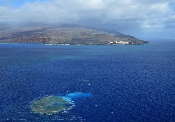
The truth is that only 50,000 years ago, El Hierro saw one of the most violent and devastating natural phenomena in record: a landslide of gigantic proportions.
In a few seconds, probably acting as a trigger for some seismic earthquake, a large piece of the island broke and rushed down the sea slope to later spread across the ocean floor. Like the wound of a colossal claw, the impressive amphitheater of the El Golfo valley appears. It is difficult to imagine a landslide of more than 300 km3, a volume corresponding to 100 times that of the ST.Helens volcano.
It is believed that the tsunami wave, produced by the El Golfo landslide, must have exceeded 100 meters in height and it is more than likely that its effects were felt on the American coasts.
Thousand volcanoes
El Hierro has the highest density of volcanoes in the Canary Islands, with more than 500 open-air cones and another 300 covered by more recent lava flows. Although the island's caves and volcanic tubes have yet to be exhaustively investigated, some 70 have already been cataloged. Some of them are very notable for the beauty of their staphyllites or for their extension, as in the case of Don's cave. Justo, whose set of galleries exceeds 6 km in length, being among the longest in the world. It is currently closed to protect an endemism in the cave.
The geography conditions the climate of the island, affected, like the rest of the Canary Islands by the trade winds, with an enviable weather throughout the year and average temperatures of its waters between 18 and 20 degrees. In turn, it stands out for its rich flora and fauna, with innumerable endemic species and some endangered species, such as the emblematic El Hierro Giant Lizard (Gallotia simonyi).